

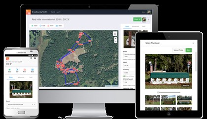
Mike Etherington Smith used the Toolkit to design at Red Hills International in Florida.
© Equimaps
Australian family business, Equimaps is dedicated to improving the experience of riders, officials and spectators in the sport of eventing through innovation and excellent design. Their bespoke mapping services have been used at big events such as Badminton Horse Trials, and are contributing to our sport becoming more spectator friendly — while also making life easier for organisers!
Organisation and course designing in the world of Eventing is being revolutionised with the launch of a new and innovative CrossCountry Toolkit software by Equimaps, creators of the popular CrossCountry App which is used around the world to create interactive maps of cross country courses.
The app is easy to use and works across all devices.
© Equimaps
The CrossCountry Toolkit provides event organisers and cross country course designers with powerful tools to design and document their courses, from the earliest ideas through construction to pro-ducing fully automated print maps for their programme and on event. Using the Toolkit saves organisers, course designers and builders both time and costs.
The software was extensively trialled by some of the worlds’ leading designers, including Mike Etherington-Smith, designer of the cross country courses at two Olympics and numerous top level courses in Europe, the USA and Australia. “It is very useful for course designers and organisers when working long distance,” says Etherington-Smith who also praises the support given by the Equimaps team.
Powerful collaboration tools allow the whole event team to work from a single private interactive map and changes are visible instantly. It takes out the guesswork for the course builder when instructions, photos or sketches can be attached to each fence. Often, certain conditions require last minute changes such as taking out a fence or moving the finish. Previously, this required time consuming and error prone edits to maps and lists. The toolkit exponentially reduces time taken for edits and automates renumbering fences and updating distance and times.
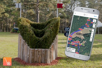
A snapshot from Red Hills, where the CrossCountry Toolkit was used to design and map the course.
© Equimaps
“The ability to map our courses, share them across continents, and collaboratively refine the maps prior to publication, without redrawing them, makes preparation of maps for competitors and for publication ever so much easier than the task once was,” says Jane Barron, Organiser at Red Hills International in Florida.
Leading French course designer Pierre le Goupil, whose courses include Haras du Pin and Lignières had been using generic mapping and drawing tools for many years but found them limited when it came to interacting with builders, organisers and officials. Creating clear maps was much too time consuming and cost prohibitive “The CrossCountry Toolkit brings all that was missing. It changes the cross country design paradigm – a revolution!” says Le Goupil.
Together with the CrossCountry App, the CrossCountry Toolkit is used by events at all levels of the sport, from the world famous
Mitsubishi Motors Badminton Horse Trials to local Pony and Riding Club One Day Events.
Once the courses are finalised, the maps can be published and added to an events’ website, increasing event promotion and engaging riders and spectators in the lead up. Spectators and riders view them online or download to CrossCountry App. It all makes for a more enjoyable experience at the event. Spectators can find their way around using the GPS accurate Smartphone map. Riders feel better prepared for the challenges of cross country and can ride at the correct pace.
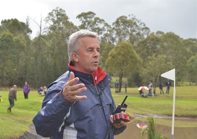
Mike Etherington Smith is a fan of the technology.
© Equimaps
“It is an incredible tool for riders to prepare for the competition, spectators to experience the whole of the courses, and certainly to afford the organisers the ability to show the courses to the world” says Jane Barron.
The addition of audio commentary, sponsor branding and video alongside fence photos creates a “virtual guided course walk”, further engaging online fans and promoting Eventing and its sponsors to a wider audience.
These course walks have been created for top events including the UK’s famous Badminton Horse Trials where Director Hugh Thomas stated “Badminton fans hugely enjoyed becoming armchair experts”
Source: Press release
READ THE LATEST NEWS ARTICLES HERE